|
GIS Mapping 
Quemahoning (Kwee-ma-hone-ing) A Delaware Indian name meaning "pine tree lick" Also the name of a creek in Quemahoning Township, Somerset County, Pennsylvania. © Quemahoning LLC 2018 |
| Quemahoning LLC Cultural Resource Management and Heritage Services |
GIS Mapping
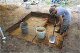
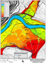
Clear, accurate maps are the most important medium for conveying archaeological data to project managers, regulatory reviewers, and the general public. Geographic Information Systems (GIS), electronic survey instruments, and GPS have become vital tools in conducting archaeological surveys and creating high-quality reports. Quemahoning has developed methods and procedures for mapping and interpreting large-scale heritage resources, including historic mine workings, ruins associated with large industrial complexes, and cultural landscape features.
|
Featured
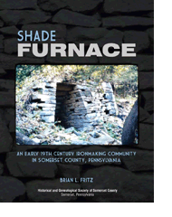
Projects
Scripture Rocks Heritage Park, Jefferson County Historical Society The Scripture Rocks is the largest collection of historic rock art in Pennsylvania. More than 160 individual sandstone boulders were engraved with Biblical verse, prophecy, and personal observations by Douglas M. Stahlman from 1911 to 1913. Field surveys completed by Quemahoning were used to create detailed maps of rock art sites. Individual panels of engrave text were delineated within the maps. The maps were used by the Jefferson County Historical Society to design and build the Scripture Rocks Heritage Park, now open and free to the public just off Interstate 80 near of Brookville, Pennsylvania. Shade Furnace Ironworks, Historical and Genealogical Society of Somerset County Quemahoning completed archaeological mapping of the 200-acre Shade Furnace Archaeological District for the site's successful nomination and listing on the National Register of Historic Places. From 1808 to 1858 raw iron ore dug from the ground was converted into cast iron and wrought iron. The maps preserve location information of important ruins and sites that are dispersed throughout the archaeological district. The archaeological mapping was a vital component in the interpretation of this important heritage site. Arroyo Tannery Heritage Site, U.S. Forest Service The industrial ruins of Arroyo Tannery and Arroyo Village stretch across an area encompassing 40 acres within the Allegheny National Forest. Field surveys completed by Quemahoning were used to generate detailed maps of the extensive ruins of this former leather tanning complex. The results of the survey were used by the Forest Service to protect and interpret this important heritage site. Spring Creek Standard Silicon Glass Sand Works - U.S. Forest Service The Spring Creek Standard Silicon Glass Sand Works include the ruins of a multi-pit mine complex, a 600-foot long incline, and massive sand processing facility that cover more than 15 acres of rugged terrain within the Allegheny National Forest. Field surveys completed by Quemahoning were used to produce detailed maps of the ruins and aided in the interpretation of the site. The results of the survey were used by the Forest Service to protect and interpret this important heritage site. |